White Mountain Guide: A Comprehensive Overview
Navigating the White Mountains demands preparation, as trails can be narrow, steep, and icy, especially during spring snowmelt; conditions shift rapidly․
The White Mountains of New Hampshire represent a premier hiking destination, famed for challenging terrain and breathtaking vistas․ This range attracts adventurers of all levels, though preparedness is paramount due to its unpredictable weather and demanding trails․ From gentle woodland walks to rigorous ascents of 4,000-foot peaks like Mount Washington, the Whites offer diverse experiences;
However, the mountains’ allure is coupled with inherent risks․ Hikers must be aware of rapidly changing conditions, potential for hypothermia, and the technical difficulties presented by steep, rocky paths․ Understanding trail markings, navigation skills, and appropriate gear are crucial for a safe and enjoyable journey․ The region’s popularity, particularly during fall foliage, means trails can become crowded, necessitating early starts and careful planning․ This guide aims to equip you with the knowledge needed to explore the White Mountains responsibly and confidently․
Geographical Overview & Key Ranges
The White Mountain National Forest encompasses approximately 750,000 acres of the White Mountains, stretching across New Hampshire and Maine․ The Presidential Range is arguably the most iconic, featuring Mount Washington, the highest peak in the Northeastern United States, and surrounding summits like Mount Adams and Mount Jefferson․ Franconia Ridge, known for its exposed alpine terrain and stunning views, presents another popular hiking area․
Other significant ranges include the Pemigewasset Wilderness, offering remote and challenging backcountry experiences, and the Carter-Moriah Range, characterized by rugged peaks and dense forests․ The terrain varies dramatically, from gentle slopes to precipitous cliffs, demanding respect and careful route selection․ Understanding the layout of these ranges is vital for planning hikes appropriate to your skill level and ensuring a safe and rewarding adventure within this diverse landscape․
Planning Your Hike
Careful planning is crucial; weather changes quickly, trails can be treacherous, and proper gear alongside physical fitness are absolutely essential for safety․
Best Time to Visit: Seasonal Considerations
Optimal hiking seasons in the White Mountains are generally late spring, summer, and early fall, though each presents unique challenges․ Spring (late May-June) offers blooming wildflowers but also lingering snow, icy trails, and potentially difficult river crossings due to snowmelt․ Summer (July-August) boasts warmer temperatures and generally drier conditions, making for pleasant hiking, but it’s also the most crowded time․
Fall (September-October) is renowned for spectacular foliage, drawing large crowds; parking fills quickly, and weather becomes increasingly unpredictable․ Winter (November-April) is for experienced winter mountaineers only, requiring specialized gear and avalanche awareness․ Be aware that even during peak seasons, conditions can change rapidly, demanding preparedness for all types of weather․ Spring is particularly tricky, with variable conditions and potential for lingering snow․
Understanding White Mountain Weather
White Mountain weather is notoriously unpredictable and can change dramatically within hours, even during summer․ Rapid shifts are common, with sunshine quickly turning to fog, rain, or even snow at higher elevations․ Temperatures can plummet unexpectedly, and strong winds are frequent, especially above treeline․ Hikers must be prepared for all conditions, regardless of the forecast․
Monitoring weather forecasts before and during your hike is crucial․ Pay attention to temperature, wind speed, precipitation probability, and potential for thunderstorms․ Be aware of the elevation gain and how it will affect temperatures․ Conditions on Mount Washington, in particular, are extreme and warrant careful consideration․ Always pack layers of clothing and be prepared to turn back if the weather deteriorates․
Required Gear & Equipment Checklist
Essential gear for White Mountain hiking includes sturdy hiking boots, waterproof and windproof outer layers, and moisture-wicking base layers․ Pack plenty of food and water – more than you think you’ll need – and a reliable water filter or purification tablets․ A well-stocked first-aid kit is non-negotiable, alongside a headlamp or flashlight with extra batteries․
Navigation tools are vital: a map, compass, and GPS device (with extra batteries) are crucial, and know how to use them․ Trekking poles can significantly aid balance and reduce strain on knees, especially on steep terrain․ Don’t forget sun protection – sunscreen, sunglasses, and a hat – even on cloudy days․ Consider bringing insect repellent, and a whistle for signaling in emergencies․
Physical Fitness & Preparation
Hiking in the White Mountains demands a high level of physical fitness․ Prioritize cardiovascular training – running, cycling, or swimming – to build endurance․ Incorporate strength training, focusing on legs and core, to handle steep ascents and descents․ Practice hiking with a weighted pack to simulate trail conditions and break in your boots․
Gradually increase your hiking distance and elevation gain over several weeks before your trip․ Familiarize yourself with scrambling techniques, as many trails involve rock climbing․ Understand your limits and choose trails appropriate for your fitness level․ Proper preparation minimizes risk and maximizes enjoyment․ Listen to your body and rest when needed; the mountains will still be there․

Popular Hiking Trails
Iconic routes like Tuckerman Ravine, Caps Ridge, Franconia Ridge, and Presidential Traverse offer diverse challenges, while Owl’s Head via Lincoln Brook is a must-do․
Mount Washington: Via Tuckerman Ravine
Tuckerman Ravine presents a formidable ascent to Mount Washington, widely considered one of the most challenging hikes in the White Mountains․ This south-facing approach is renowned for its steep terrain and potentially hazardous conditions, particularly during spring․ Hikers should be prepared for significant elevation gain over a relatively short distance, demanding excellent physical fitness and mountaineering skills․
The ravine is infamous for its unpredictable weather and potential for avalanches, even late into the season․ Careful assessment of snow conditions and avalanche forecasts is crucial before attempting this route․ Beyond the technical challenges, Tuckerman Ravine offers breathtaking views and a unique alpine experience for those prepared to tackle its difficulties․ It’s a popular, yet demanding, path to the summit, attracting experienced hikers seeking a true test of their abilities․
Mount Washington: Via Caps Ridge & Link/Castle Trail
Ascending Mount Washington via Caps Ridge offers a direct, albeit steep and rocky, route to the summit․ It’s a popular choice, but demands solid footing and stamina․ Alternatively, the Link/Castle Trail presents a more secluded, and considerably more dangerous, option․ This path, part of the “Terrifying 25” list, sees less traffic and features more challenging terrain, requiring advanced hiking experience․
Choosing between these routes depends on your skill level and risk tolerance․ Caps Ridge is strenuous but generally well-maintained, while Link/Castle demands careful navigation and a high degree of self-sufficiency․ Both routes expose hikers to the mountain’s unpredictable weather, so preparedness is paramount․ Consider the potential hazards and choose a path that aligns with your capabilities․
Franconia Ridge Loop: A Classic Hike
The Franconia Ridge Loop is renowned as one of the White Mountains’ most spectacular hikes, offering panoramic views and challenging terrain․ This approximately 8․9-mile loop traverses Little Haystack, Mount Lincoln, and Mount Lafayette, exposing hikers to stunning alpine scenery․ Expect exposed ridgelines, requiring careful footing, especially in windy conditions․
This hike is best suited for experienced hikers due to its length and elevation gain․ Be prepared for potentially muddy and technical sections, and always check the weather forecast before embarking․ Fall foliage draws large crowds, so consider an early start to secure parking and enjoy a less congested trail experience․ Proper gear, including layers and ample water, is essential for a safe and enjoyable journey․
Presidential Traverse: For Experienced Hikers
The Presidential Traverse is a legendary, incredibly demanding hike across the Presidential Range, encompassing Mount Washington, Mount Adams, Mount Jefferson, and more․ This strenuous route, typically completed over multiple days, tests even seasoned hikers with its relentless elevation gain, exposed terrain, and unpredictable weather․ Navigation skills are crucial, as conditions can change rapidly, and visibility can be severely limited․

This traverse is strictly for experienced mountaineers with excellent physical fitness and preparedness․ Expect significant rock scrambling, potentially dangerous river crossings after snowmelt, and the possibility of encountering severe weather, including high winds and freezing temperatures; Thorough planning, appropriate gear, and a realistic assessment of your abilities are paramount for a safe completion․
Mount Lafayette & Franconia Ridge
Mount Lafayette, often combined with a Franconia Ridge hike, presents a stunning, yet challenging, experience․ The Franconia Ridge Loop is a classic White Mountains trek, famed for its breathtaking 360-degree views and exposed ridgeline walking․ This loop typically includes summits of Lafayette, Lincoln, and Little Haystack, offering diverse terrain and significant elevation changes․
Hikers should be prepared for potentially windy conditions along the ridge, and be mindful of rapidly changing weather․ The trail features sections of steep, rocky climbs and descents, requiring good physical fitness and sturdy footwear․ While popular, the exposed nature demands caution, especially for those unfamiliar with alpine environments․ Proper navigation skills are also essential for enjoying this iconic hike safely․

Owl’s Head Trail via Lincoln Brook
The Owl’s Head Trail, accessed via the Lincoln Brook Trail, is considered a must-do for those aiming to conquer the 4,000-footers of the White Mountain National Forest․ However, be warned: the southern portion, leading to Owl’s Head, is well-maintained, but the northern section of Lincoln Brook Trail presents significant challenges․ This area receives far less traffic and is characterized by thin, muddy, and technically demanding terrain․
Expect indistinct trail markings and challenging footing․ Hikers should possess strong navigational skills and be prepared for a rugged, less-traveled experience․ River crossings, particularly after snowmelt, can be difficult and require careful consideration․ This trail is best suited for experienced hikers comfortable with off-trail navigation and challenging conditions․

Trail Difficulty & Safety
White Mountain trails vary greatly; understanding ratings is crucial, as many are narrow, steep, and require scrambling skills for safe ascents and descents;
Trail Difficulty Ratings Explained
Understanding White Mountain trail difficulty is paramount for a safe and enjoyable experience․ Ratings aren’t standardized, varying between guidebooks and the Appalachian Mountain Club (AMC)․ Generally, trails are categorized as Easy, Moderate, or Difficult, but these are relative within the White Mountains context․ “Easy” trails often involve gentle grades and well-maintained paths, suitable for beginners, though some elevation gain is still expected․ “Moderate” trails present steeper sections, potentially rocky terrain, and require a reasonable level of fitness․
“Difficult” trails, however, demand significant physical exertion and experience․ Expect substantial elevation gain, exposed sections, scrambling over rocks, and potentially challenging navigation․ The AMC often uses a more detailed system, considering factors like elevation gain, trail length, and technical difficulty․ Always research a trail’s specifics before embarking, considering your group’s abilities and experience level․ Don’t underestimate the Whites – even “easy” trails can present challenges due to unpredictable weather and rugged terrain․
Navigating Narrow & Steep Terrain
The White Mountains are renowned for their challenging terrain, frequently featuring narrow trails and steep ascents․ Successfully navigating these sections requires careful footwork, a low center of gravity, and consistent attention․ Utilize three points of contact – two feet and a hand – when scrambling over rocks, ensuring solid holds before shifting your weight․ Scan ahead to identify potential obstacles and plan your route accordingly․
Maintaining focus is crucial; avoid distractions and be mindful of loose rocks or slippery surfaces․ Experienced hikers often emphasize that learning rock climbing techniques can significantly improve hiking footwork in these conditions․ Descending steep terrain demands even greater caution, utilizing a controlled pace and engaging your core muscles for stability․ Poles can provide additional support and balance, reducing strain on your knees and ankles․
River Crossings & Snowmelt Challenges
Spring hiking in the White Mountains presents unique challenges due to snowmelt and resulting river crossings․ Water levels can rise rapidly, transforming normally manageable streams into swift, dangerous obstacles․ Always assess the current before attempting a crossing; look for the widest and shallowest point, and unbuckle your pack’s waist belt for quick removal if needed;
Utilize trekking poles for stability, probing the riverbed for secure footing․ Consider crossing barefoot to improve grip, but be mindful of sharp rocks․ Snowmelt can also create muddy and slushy trail conditions, increasing the risk of slips and falls․ Be prepared for icy patches, even in warmer months, and wear appropriate footwear with good traction․ Early spring hikes require extra vigilance and careful planning due to these unpredictable conditions․
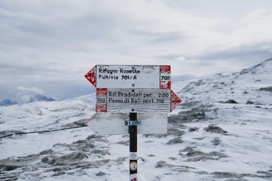
Understanding Trail Markings & Maps
Effective navigation in the White Mountains relies on understanding trail markings and utilizing detailed maps․ The White Mountain National Forest employs a system of blue blazes – vertical painted rectangles on trees – to indicate the official trail route․ However, blazes can be sparse or obscured in challenging terrain, so don’t solely depend on them․
Carry a topographic map and compass, and know how to use them; Familiarize yourself with contour lines to understand elevation changes․ GPS devices are helpful, but batteries can fail, so maps remain essential․ Pay attention to junctions and landmarks, noting their positions on your map․ Regularly check your location to ensure you’re on course, and be prepared to adjust your route if necessary․ Proper map reading skills are crucial for safe hiking․
Wildlife Encounters & Safety Precautions
The White Mountains are home to diverse wildlife, including black bears, moose, and various smaller animals․ While encounters are relatively rare, it’s vital to be prepared․ Store food securely in bear-resistant canisters or hang it properly to avoid attracting bears to campsites․ Never approach or feed wildlife; observe from a distance․

Moose can be unpredictable, especially during mating season․ If you encounter a moose, give it plenty of space and slowly back away․ Be aware of your surroundings and make noise while hiking to avoid surprising animals․ Carry bear spray as a deterrent, and know how to use it․ Report any aggressive wildlife encounters to park authorities to help ensure the safety of other hikers․

Specific Hazards & How to Mitigate Them
Rapid weather changes, hypothermia risks, and challenging terrain—including rock scrambling—demand vigilance; proper gear and preparation are crucial for safe hiking․
Rapidly Changing Weather Conditions
The White Mountains are notorious for their unpredictable and rapidly changing weather patterns, even within a single day․ Hikers must be prepared for all possibilities, regardless of the initial forecast․ Sunshine can quickly give way to dense fog, rain, or even snow, particularly at higher elevations like Mount Washington․
Temperature fluctuations are significant; conditions at the summit can be drastically colder than at the trailhead․ Wind speeds can also increase dramatically, exacerbating the effects of cold and potentially creating dangerous wind chill․ It’s essential to check the updated forecast immediately before heading out and to continuously monitor conditions while on the trail․
Pack layers of clothing to adapt to changing temperatures, including waterproof and windproof outer layers․ Be prepared to turn back if the weather deteriorates, as pushing onward in adverse conditions can quickly become life-threatening․ Awareness and preparedness are key to mitigating the risks associated with the White Mountains’ volatile climate․
Hypothermia & Altitude Sickness
Hiking in the White Mountains presents risks of both hypothermia and altitude sickness, demanding hiker awareness and proactive prevention․ Hypothermia, a dangerous drop in body temperature, can occur even in temperatures above freezing, especially when combined with wind and wet conditions․ Symptoms include shivering, confusion, and loss of coordination․
Altitude sickness affects individuals ascending to higher elevations, like Mount Washington, due to reduced oxygen levels․ Symptoms range from headache and nausea to more severe conditions like High Altitude Pulmonary Edema (HAPE)․ Acclimatization is crucial; ascend gradually and stay hydrated․
Recognize the early signs of both conditions and take immediate action․ For hypothermia, seek shelter, add layers, and consume warm fluids․ For altitude sickness, descend to a lower elevation․ Knowing your limits and being prepared to turn back are vital for a safe experience․
Rock Scrambling & Fall Prevention
Many White Mountain trails involve rock scrambling – using hands for upward progress – requiring solid technique and caution․ Trails are often narrow, steep, and demand good scrambling skills․ Experienced hikers even suggest rock climbing improves footwork for these sections․ Always test holds before committing your weight, maintaining three points of contact whenever possible․
Fall prevention is paramount․ Wear appropriate footwear with good grip, and consider trekking poles for added stability․ Scan the terrain ahead, identifying potential hazards and planning your route․ Avoid loose rocks and unstable surfaces․
Understand your limitations; don’t attempt scrambles beyond your skill level․ A controlled descent is as important as a safe ascent․ Prioritize careful foot placement and maintain focus to minimize the risk of slips and falls․

Muddy & Icy Trail Conditions
White Mountain trails are notorious for challenging conditions, particularly mud and ice․ Spring presents a tricky hiking season, with lingering snow and significant snowmelt contributing to extremely muddy trails․ River crossings become particularly difficult and potentially dangerous post-snowmelt due to increased water flow and slippery banks․
Icy conditions can persist well into spring, even on lower elevation trails․ Microspikes or crampons are often essential for safe travel during these periods․ Be prepared for slick rocks and exposed roots hidden beneath the ice or mud․
Careful footing and slow, deliberate steps are crucial․ Trekking poles provide added stability․ Consider alternative routes if conditions seem too hazardous, and always check recent trail reports before heading out․

Resources & Further Information
Explore the White Mountain National Forest website and AMC resources for detailed maps, conditions, and guidance; local outfitters offer expert support․
White Mountain National Forest Website
The official White Mountain National Forest website serves as an invaluable central hub for planning any adventure within this stunning region․ Visitors will find comprehensive and up-to-date information regarding trail conditions, closures due to weather or maintenance, and crucial safety alerts․ Detailed topographic maps are readily available for download, assisting hikers in route planning and navigation․
Beyond trail specifics, the website provides insights into permitted activities, camping regulations, and responsible recreation practices, emphasizing Leave No Trace principles․ It also features information about the forest’s diverse ecosystems, historical significance, and ongoing conservation efforts․ Regularly checking this resource before and during your trip is highly recommended, particularly given the White Mountains’ reputation for rapidly changing weather patterns and challenging terrain․ Access to current alerts and warnings can significantly enhance your safety and enjoyment․
AMC (Appalachian Mountain Club) Resources
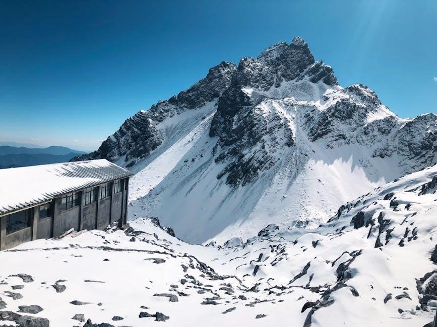
The Appalachian Mountain Club (AMC) is a cornerstone resource for White Mountain enthusiasts, offering a wealth of knowledge and support for hikers of all levels․ Their website features detailed trail guides, including elevation profiles, difficulty ratings, and recent condition reports contributed by fellow hikers․ AMC operates several backcountry huts within the White Mountains, providing lodging, meals, and valuable weather updates – reservations are essential․
Furthermore, the AMC offers educational workshops and guided hikes, covering topics like map and compass navigation, wilderness first aid, and responsible hiking practices․ Their publications, including the “White Mountain Guide,” are considered essential companions for anyone exploring the region․ Membership provides access to exclusive benefits and supports the AMC’s ongoing conservation and stewardship efforts within the White Mountain National Forest․
Local Guide Services & Outfitters
For those seeking expert guidance or needing specialized equipment, numerous local guide services and outfitters cater to White Mountain adventurers․ These businesses offer guided hiking tours tailored to various skill levels, from introductory scrambles to challenging Presidential Traverse expeditions․ Experienced guides provide invaluable insights into trail conditions, weather patterns, and safety protocols․
Outfitters stock a comprehensive range of hiking gear, including sturdy boots, waterproof apparel, navigation tools, and emergency supplies․ They can assist with gear selection and fitting, ensuring you’re properly equipped for your chosen hike․ Many offer rental options, which are ideal for visitors or those trying out new equipment․ Supporting these local businesses contributes to the White Mountain community and ensures continued access to quality services․
Emergency Contacts & Rescue Information
Prioritizing safety in the White Mountains necessitates knowing how to access help in emergencies․ In the event of an injury, sudden weather change, or getting lost, immediate action is crucial․ For life-threatening situations, dial 911; however, cell service can be unreliable in remote areas․ The New Hampshire Fish and Game Department (NHF&G) is the primary search and rescue agency․
Non-emergency assistance can be obtained through the Appalachian Mountain Club (AMC) and local park rangers; Before your hike, inform someone of your planned route and estimated return time․ Carry a fully charged cell phone, a whistle, and a map & compass (and know how to use them!)․ Familiarize yourself with the White Mountain National Forest’s safety guidelines and be prepared to self-rescue if possible․